Google Maps Murchison Falls: Complete Navigation Guide for Safari Travelers
Planning a safari to Uganda’s largest and most famous national park requires more than simply booking accommodation and packing safari gear. Understanding routes, travel times, road conditions, and navigation tools is essential for a smooth journey. Today, one of the most important travel tools for independent travelers and safari planners is Google Maps Murchison Falls navigation. Whether traveling from Kampala, Entebbe, Gulu, or other regions of Uganda, digital navigation systems help visitors understand distances, identify routes, locate accommodations, and estimate travel times more accurately.
Murchison Falls National Park is located in northwestern Uganda and covers a vast area of savannah, woodland, wetlands, and river ecosystems surrounding the Nile River. The park’s size and remote setting make navigation planning particularly important, especially for self-drive travelers or visitors organizing private road safaris. Although professional tour operators usually manage transportation logistics for guided safaris, many travelers still use Google Maps for orientation, location tracking, and route confirmation during their journey.
Digital navigation has significantly improved safari accessibility in Uganda, but visitors should also understand its limitations in remote wildlife areas. Internet coverage, road signage, park gate locations, and offline map preparation all influence the effectiveness of navigation systems inside and around Murchison Falls National Park.
This guide explains how to use Google Maps effectively for Murchison Falls safaris, including route planning, park access, offline navigation, travel safety, and practical road travel advice for Uganda safari visitors.
Understanding the Location of Murchison Falls National Park
Before using Google Maps Murchison Falls, travelers should understand the park’s geography and regional positioning within Uganda. Murchison Falls National Park lies approximately 305 kilometers north of Kampala and stretches across several districts including Masindi, Nwoya, Kiryandongo, and Buliisa.
The park is divided by the Victoria Nile, creating northern and southern sectors connected by ferry crossings and road networks. Different safari lodges are located in various sections of the park, which means navigation routes may vary depending on accommodation choice and safari activities.
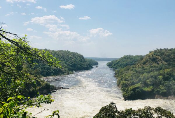
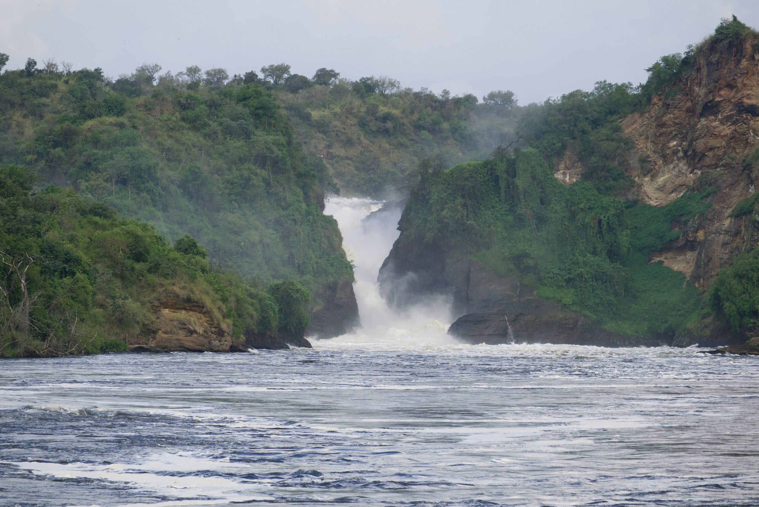
Murchison Falls itself is the dramatic point where the Nile River forces through a narrow gorge before plunging downward into powerful rapids. This iconic attraction is located near the center of the park and is accessible through designated game-viewing roads and hiking areas.
Using Google Maps allows travelers to visualize the park’s vast size and understand how safari circuits connect across different wildlife zones.
How to Get to Murchison Falls Using Google Maps
One of the most common searches by safari travelers is how to get to Murchison Falls from Kampala or Entebbe. Google Maps provides multiple route options depending on the traveler’s starting location, preferred roads, and final destination inside the park.
The most frequently used road route from Kampala passes through Luweero, Nakasongola, and Masindi before reaching the southern gates of the park. The journey typically takes five to seven hours depending on traffic, weather, and road conditions.
Travelers approaching from northern Uganda may enter through routes connected to Gulu or Pakwach. Some luxury safari itineraries also combine road travel with domestic flights to nearby airstrips within the park.
Google Maps helps estimate driving times and fuel requirements, though travelers should allow additional time for wildlife sightings, photography stops, and occasional road delays.
Murchison Falls Directions and Park Gates
Understanding Murchison Falls directions is especially important because the park has multiple entry gates serving different regions and lodges. The most commonly used gates include Kichumbanyobo Gate, Tangi Gate, Mubako Gate, and Wankwar Gate.
Each gate connects to different sections of the park and may influence access to safari activities such as game drives, boat cruises, or waterfall hikes.
Google Maps can help travelers identify which gate is closest to their lodge or safari itinerary. However, visitors should confirm directions directly with safari operators or accommodations because some remote roads may not appear accurately on navigation systems.
Certain safari lodges provide custom GPS coordinates for easier access, especially in wilderness areas with limited signage.
Uganda Safari Navigation and Road Conditions
Although Uganda safari navigation has improved greatly through digital mapping, travelers should still prepare for changing road conditions in rural areas. Main highways connecting Kampala to Masindi are generally paved and reliable, but roads inside the national park are primarily dirt tracks designed for safari vehicles.
During the rainy season, some roads may become muddy or difficult for standard vehicles. Safari travelers should therefore avoid relying entirely on automated navigation without local knowledge.
Google Maps provides useful orientation and estimated travel times, but professional guides understand road conditions, wildlife movement patterns, and seasonal accessibility far better than digital systems alone.
For self-drive visitors, using a reliable 4×4 vehicle remains strongly recommended when exploring Murchison Falls National Park.
Offline Maps Uganda Safari Preparation
One of the most important tips for using offline maps Uganda safari navigation is downloading maps before leaving urban areas. Mobile internet coverage inside national parks can become inconsistent, especially in remote wildlife zones.
Google Maps allows users to download large map sections for offline use. This feature is essential for travelers driving independently or navigating between lodges and park gates.
Offline maps continue functioning even without mobile signal, allowing travelers to track routes and monitor location throughout the safari.
Visitors should download:
Kampala to Murchison Falls routes
Masindi region maps
National park road networks
Lodge locations and nearby landmarks
Offline preparation significantly improves navigation reliability during Uganda safaris.
Google Maps Accuracy Inside Murchison Falls
While Google Maps Murchison Falls navigation is highly useful, travelers should understand that some internal safari tracks may not appear perfectly accurate. National parks constantly adjust road access depending on weather, wildlife activity, conservation projects, and maintenance work.
Some remote safari tracks may appear incomplete or unnamed on digital maps. In these situations, guidance from rangers, safari guides, or lodge staff becomes more reliable than automated directions.
Travelers should also avoid driving unfamiliar park roads after dark, even if maps indicate accessibility.
The combination of digital maps and local safari expertise creates the safest and most effective navigation strategy.
Fuel Stations and Travel Planning
Long-distance safari travel requires careful fuel planning. Using Murchison Falls road trip navigation tools helps travelers identify fuel stations before entering remote park areas.
Major fuel stops are available in towns such as Masindi, but fuel stations become less frequent closer to wildlife areas. Visitors should avoid entering the park with low fuel levels.
Google Maps can assist with locating fuel stations, supermarkets, restaurants, and accommodation options along the route.
Safari travelers should also carry drinking water, snacks, emergency supplies, and backup charging equipment during long road journeys.
Navigation Safety During Uganda Safaris
Responsible Uganda safari travel guide planning includes navigation safety awareness. Travelers should avoid driving at high speeds, especially in wildlife areas where animals may suddenly cross roads.
Night driving is generally discouraged in Uganda’s rural regions due to limited lighting and wildlife movement. Early departures from Kampala are recommended to ensure arrival at Murchison Falls during daylight hours.
Travelers should also share route plans with lodges or tour operators before departure, especially during self-drive safaris.
Using Google Maps responsibly means combining digital convenience with practical safari safety precautions.
GPS Coordinates and Lodge Locations
Many travelers use Murchison Falls GPS location searches to find safari lodges, camps, and activity starting points. Luxury lodges, tented camps, and midrange accommodations often provide direct GPS coordinates to simplify navigation.
Because some lodges are located deep within conservation areas, relying only on general park searches may lead travelers to incorrect entrances or unnecessary detours.
Visitors should always confirm exact lodge directions before departure.
Professional safari operators booking through Murchison falls park safari usually provide clear travel instructions, route recommendations, and transfer support for visitors traveling by road or air.
Why Guided Safaris Still Matter Despite Google Maps
Although digital navigation tools are valuable, they do not replace professional safari expertise. Wildlife behavior, changing road conditions, ferry schedules, and conservation restrictions all influence safari movement within the park.
Guided safaris provide not only transportation but also wildlife interpretation, safety support, logistical coordination, and local knowledge that digital systems cannot replicate.
Travelers using Google Maps for orientation still benefit greatly from experienced safari guides during game drives and wildlife exploration.
Exploring Murchison Falls Beyond Navigation
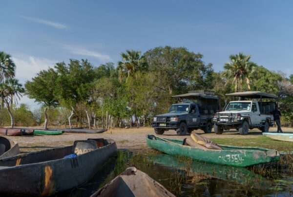
Using Google Maps Murchison Falls effectively helps travelers reach the park smoothly, but the true safari experience begins after arrival. Murchison Falls National Park offers exceptional wildlife viewing, Nile River cruises, birdwatching, hiking, and cultural interactions that extend far beyond simple navigation.
Visitors can experience:
- Game drives in the northern savannah
- Boat safaris to the base of the falls
- Hiking to the top of Murchison Falls
- Birdwatching excursions
- Cultural community visits
- Nile Delta exploration
Travelers exploring Murchison falls national park can discover safari itineraries designed to combine navigation convenience with unforgettable wildlife experiences.
Technology and Modern Safari Travel
Digital tools such as Google Maps have transformed modern safari travel by improving accessibility, trip planning, and traveler independence. Visitors can now estimate distances, compare routes, locate lodges, and navigate rural Uganda more confidently than ever before.
However, technology works best when combined with practical travel awareness and local expertise.
Preparation, downloaded maps, reliable vehicles, and professional guidance remain essential for successful safari adventures in Uganda.
Final Thoughts on Google Maps Murchison Falls
Using Google Maps Murchison Falls navigation is an excellent way to improve safari planning, understand travel routes, and organize transportation throughout Uganda. From Kampala road trips to internal park orientation, digital maps provide valuable support for modern safari travelers.
However, visitors should combine navigation technology with local safari knowledge, offline preparation, and responsible travel practices. National parks remain dynamic wilderness environments where conditions can change quickly.
With proper preparation, travelers can enjoy smooth navigation, safer journeys, and unforgettable wildlife experiences while exploring Murchison Falls National Park and the surrounding regions of Uganda.